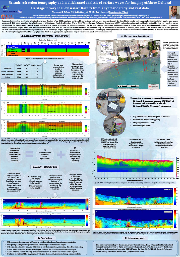
Seismic refraction tomography and multichannel analysis of surface waves for imaging offshore Cultural Heritage in very shallow water: Results from a synthetic study and real data

In archaeology, applied geophysics helps to discover new findings of our hidden cultural heritage. However, these methods have been particularly developed in terrestrial environments, leaving the shallow marine ones almost unexplored. This paper examines the effectiveness of Multichannel Analysis of Surface Waves MASW and Seismic Refraction Tomography SRT οn imaging submerged and buried antiquities in a very shallow marine environment.

Satellite-Derived Bathymetry for the Islands of South-Eastern Crete

Recent advances in remote sensing techniques and higher availability of satellite sensors has increased their applicability to several scientifc sectors, including marine research and coastal cultural heritage management. Satellite-derived bathymetry is relatively simple, cost-effective, and time-effective method to extract high resolution bathymetry model. The method has been applied to Koufonisi and Chrisi islands off the coast of south-eastern Crete in southern Greece. The islands’ waters have not yet been investigated for their potential value to cultural heritage in the area.

Reconstructing Submerged and Buried Cultural Heritage from Shallow Water to Digital Environment with Geoinformatics

Time, space and human intervention, are responsible for the conservation of ar-chaeological remains and cultural heritage (CH) in general. Under this framework the project “ClepsYdra will integrate the archaeological research with state-of-the-art methodologies and innovative technological aspects for the documentation and promotion of CH adapt-ing equipment and practices to the shallow underwater context.

Multi-Frequency Loop Electromagnetic System Measurement on Shallow Offshore Archaeological Site of Oulos

Marine environments are characterized by a rather high electrical conductivity. This particular setting allows electromagnetic induction to operate at high induction number, even for relatively low frequency and/or small source-receiver distances. We study the feasibility of imaging the sub seafloor medium with a rigid-boom multi-frequency loop-loop FDEMI instrument floating on very shallow aquatic environment with bathymetry less than 2m.

Contact Us

Laboratory of Geophysical - Satellite Remote Sensing and Archaeo-environment

Institute for Mediterranean Studies

Foundation for Research and Technology - Hellas

Project Coordinator

Nikos Papadopoulos, Research Director

Collaborating Organizations